Grove Hill House - The Abbey That Never Was
 One of West Kirby's most impressive buildings, Abbey Manor is almost completely overlooked by the thousands of motorists who pass it every day. The building is obscured from public view, yet it is almost a miniature stately home in our midst. It belonged to one of the most important men in the history of the town and was set within acres of landscaped gardens. But why does it have the word "Abbey" attached? And what is left to see today?
Taking a walk away from the modern town centre, past the White Lion and up Grange Road hill, you would begin to notice clues to an ecclesiastical presence in the town. As you continue to walk up the hill you would pass Abbey Road, before seeing a gigantic, grey pebble-dashed house bearing the name Abbey Manor on the gate. This is followed by a collection of buildings called Abbey Mews and finally the road Monk's Way, leading to Priory Road. You would therefore be forgiven for drawing a fairly obvious conclusion - that there must have been an Abbey here at some point.
The story begins four thousand years ago, at a time when the hill overlooking the Dee was of importance to the early Bronze Age inhabitants of the Wirral. Dating from between c. 2200 and 1400 BC, a cordoned urn dug up in the 20th century reveals that the site had been in use long before the Romans arrived on our shores.
Through the first millennium AD the Wirral's Viking story unfolded before the Norman Conquest changed the country. A hundred years after that, across the estuary near Holywell in North Wales lived the Monks of Basingwerk Abbey in the 12th century. They received the manor of West Kirby from the Earls of Chester and upon the top of the hill overlooking the mouth of the Dee they established a farm, or monastic grange.
For hundreds of years these monks were the medieval land-owners there, and a community of houses arose along the hill which lead to the River Dee. Over on the other side of the hill another settlement grew up in the shadow of St Bridget's church to become what's now called 'The Old Village'.
19th Century Developments
 Much of the early story of the house remains to be untangled, but owners from the 1960s claimed that the earliest surviving sandstone building on the site was an old Sunday School House.
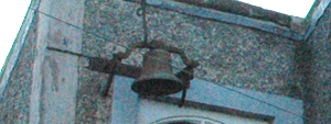
Further research and investigation on the building remains to be done, however from the road today an old bell can be seen high up on the wall (pictured above), and it is said that this was the school bell. 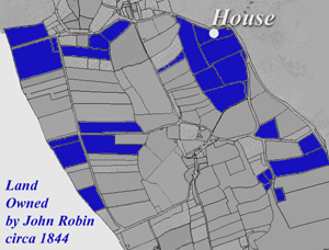 The precise date for this supposed Sunday School building is unknown, but what is certain is that the section to which the bell is attached is smaller, older and less lavish than that which came later.
It was in 1819 that the wealthy, Jersey-born merchant John Robin purchased the Lordship of Frankby, and tithe maps of later decades record him as being one of the village's ten biggest land-owners. The map to the right shows his property in blue scattered throughout the area but he set his sights on the top of the hill which had been occupied by the Monks' farm in West Kirby. And so on the site of the old farm, and incorporating that which was said to have been the Sunday School building, John Robin set about building a magnificent home for himself and his family.
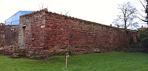
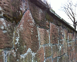
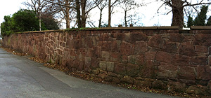 It is no co-incidence that another Jersey-born man arrived soon after to help with additional building work. Stone mason Philip De Gruchy (also written as 'Degruchy' and 'De Grouchy') was brought in by his fellow Channel-islander John Robin, seemingly for the specific job of building the high perimeter wall from local red sandstone.
De Gruchy used gigantic pieces of irregular stone, some more than a metre across, cut with efficiency and held together with very little mortar. A surviving section of the original wall is pictured above right. This style of construction is virtually unique in West Kirby and for a more detailed discussion about De Gruchy's walls, click here.
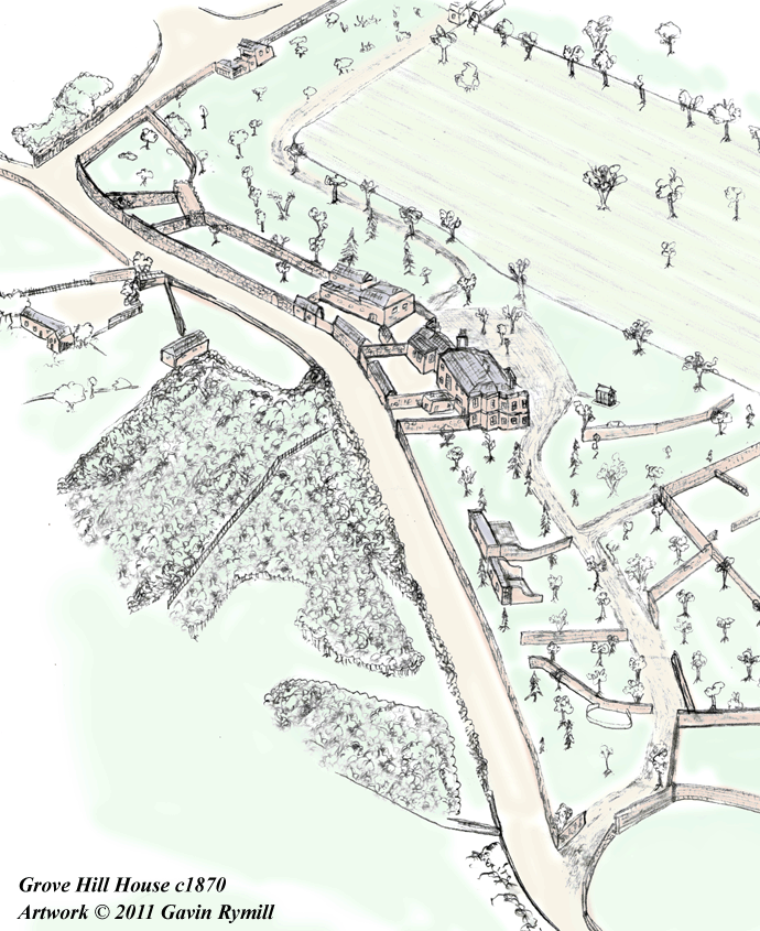
 By the end of 1830s, a large, impressive house stood, surrounded by high sandstone walls. The house's Georgian frontage faced down the hill which afforded John Robin a stunning view of the estuary.
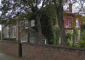
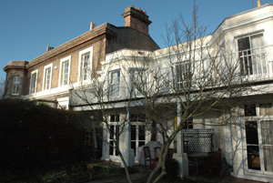
The house as viewed in the 1840s had three visually distinct components to it. The west half of the house was a newer, taller, two storey house with high ceilings. The central portion of the house was the smaller Sunday School House (to which bay windows were added much later), and lastly the east end was a block for the servants quarters. The two grander sections of the house are pictured in this photograph.
There were three ways to enter the house. The gate at the corner (opposite what is now Gerard Road) took a route from the west and would have shown the front of the house in its magnificence. At the top of the road, to the east, opposite what is now Black Horse Hill, was "The Lodge". Coaches approaching the house would have enjoyed a ride through the gardens and unusual trees, as was the tradition at the time for the wealthy to impress their vising guests via the driveway approach.
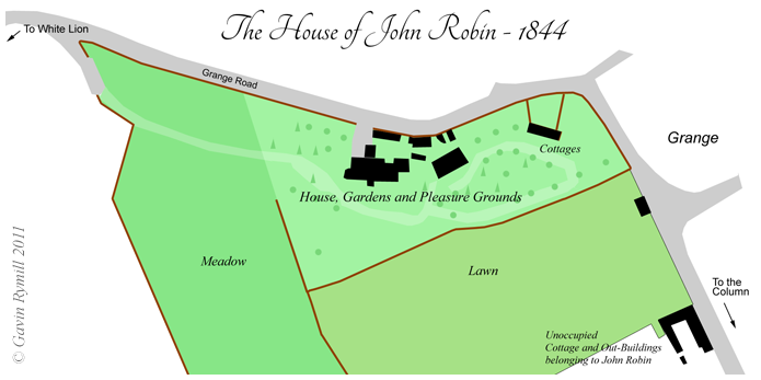
 Via the west entrance (pictured right with later wall and gate), a visitor would first pass what was marked on early maps as "meadow" and then enter the Pleasure Grounds as the route snaked around the magnificent front of the building.
There was a more practical entrance via a yard at the side of the house, which adjoined Grange Road. This main road butted up closely against the high sandstone rock face, which had been reinforced with additional brickwork. It is a sad consequence of the house being aligned towards the coast that today the only public view of the house is from here. Little wonder then that this impressive place is hardly appreciated, as most locals have only ever seen the functional, angular rear of the building.
 The 1841 census shows the son Charles Robin, also a merchant, was at home but the father John Robin was absent. Living there at the time were Robert Ellison and John Peacock, both living off independent means, i.e. they had income from their investments rather than actually working. Living alongside them were servants Jane Atkinson, Betty Langley and Richard Hale. Nearby was Charles Barlow, a labourer, whose cottage walls still stands within the perimeter of the grounds. The photograph above shows the cottages, which are marked on the 1844 map. (Census image here).
In the 1841 census, the stone-mason Philip De Gruchy can be found staying with John and Esther Rainford at Grange - the former monastic site from which the term "Abbey" springs. The census records that he was born in "foreign parts"! The Rainford family had been the millers at Grange windmill for four generations until it was destroyed in the great storm of 1839.
In the 1840s De Gruchy had become owner of a small plot of land off what would become Darmond's Green. Local legend says that he was gifted this land in recognition of his contribution to the town, but how he came to acquire it is unknown. 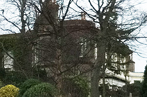 The records of the time show that he was the owner but not the occupier of this property. It was lived in by Ann Taylor, a 35-year-old labourer's wife, and perhaps her husband John had worked on the house or its grounds.
In the 1851 census he is listed as being both a grocer and stonemason. This time the document more helpfully confirms he is from Jersey. He also appears as a stonemason in Bagshaw's Directory in 1850 and as a shopkeeper at West Kirby in Kelly's 1857 Directory for Cheshire.
Curiously, the wall itself even made the papers when in 1854, three marauding labourers looking for trouble, knocked down a section and were brought before the courts. To read the full news report, click here.
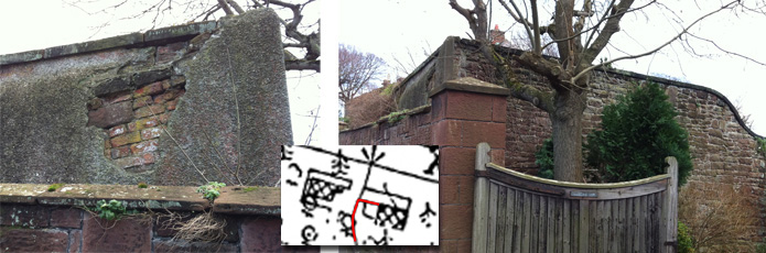
In the years that followed its completion, the grounds continued to develop. The route towards the house saw new brick out-buildings constructed, with different areas of the gardens sectioned off by the same high red walls. Today, in the back garden of one house, a small section of wall still exists, and through the crumbling plaster, the brickwork of the ancient out-building is visible which formed part of its length. The photographs below show this surviving fragment, and inset is the section of a map from 1871 showing the relevant section, with the extant wall marked in red.
Two Victorian summer houses were built - one not far from the south face of the house, and another larger one down alongside "The Meadow". The walls around the larger Summer House were built up from a small cliff in the sandstone rock, creating a promontory from which the little building looked down the hill.
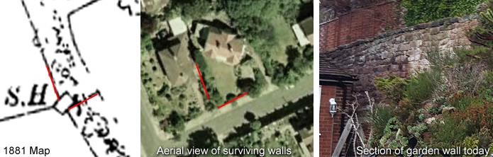
The old wall by the Summer House still survives as part of the front garden wall of a house on Monk's Way. The modern property is roughly on the same alignment and enjoying the same view, rather than running parallel to the road like the other houses in the street. The images below show the old map (left), how it matches the modern property (middle) and one of the sections of wall still standing in a private garden, as seen from the road.
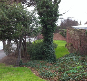
The lawn of John Robin's house was lined with trees, and half a dozen were dotted within it. Unusual specimens were collected and planted from all over the world, including trees from the Mediterranean, and the large trees around the modern houses today are all a legacy of this Victorian garden. A Japanses Garden also featured within the grounds and a visitor to the house would have been impressed by the interesting diversity of specimens.
The adjacent plots of land were soon absorbed into the grounds of the house, and with the abundance of flora, the house itself became known appropriately as Grovehill. New walls were added to divide the land around the cottages and other small changes were made. During the early 20th century, the expanding new town centre began to encroach nearer and nearer to the gardens.
The 20th Century and the Coming of the Motor Car
By 1910, a new name for the house had emerged. Having been built near the site of the Basingwerk monks' farm, a memory of this must have lingered on, but in the hundred years since the Robin family bought the land, the precise nature of the monks' work had seemingly been lost, and the name "Abbey Manor" was erroneously created.
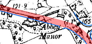 In the decade that followed, the entire area saw drastic changes. With the increased popularity of the motor car, it was decided that the dangerous blind-bend by the Cottages on Grange Road needed to be straightened out. The local council paid £3,500 in 1924 to purchase land from Abbey Manor and make improvements to the road.
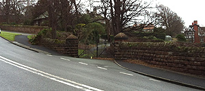
The map above right shows the course of the new road in red, slicing straight through the gardens, and nearly a quarter of a mile of De Gruchy's impressive sandstone walls were demolished. In their place, new, smaller, neater walls were erected which ran parallel to the course of the new road, which are marked in blue.
 Included within this new wall is a stone heart which local legend incorrectly purports to have been placed there by De Gruchy after his proposal of marriage to a local washerwoman was spurned. In fact, the wall with the heart was built over fifty years after De Gruchy's death, and the story seems to have been jumbled together with the lost love of a later stone mason.
During the 1920s when road was widened and the new wall was erected, one man who worked on the rebuilding of the wall had his heart broken, and it was he who placed the stone heart there. It is said that he was in love with one of the daughers at the house, hence the stone hear appears directly outside Grove Hill, or Abbey Manor as it had become by then.
It is said that the daughter in question went to America, and that the balcony on the front of the house which was added later was made in the colonial style by her father, either to tempt her back or make her feel comfortable upon her return to England. This tale, if true (and if it truly refers to the same daughter) is not connected to the heart however, since the maps show the colonial-style balcony is already in place by 1911, and therefore not associated with the rebuilding of the wall over a decade later.
In the following decades of the 20th century, more modifications were made to the house. A large, octagonal corner tower was added to the west end which increased the size of the drawing room. The two separate buildings which had been unified by Robin's construction, were divided back up again and the impressive entrance was blocked up, leaving the grand staircase inside the house facing a blank wall. A new, less grand entrance was created slightly further over, with a smaller portico.
De Gruchy and His Legacy
As for De Gruchy himself, he lived in West Kirby for a number of years, and remained a well-loved and respected character. It is believed he was involved in the construction of what became the Lear Home of Recovery, and following his years as a mason he took a shop in the road which now bears his name (or a version of it) - De Grouchy Street. He made soap and barm, and was known to be scrupulously honest. He was meticulous is in not only his work but his lifestyle, weighing everything he ate, and he visited homes to sing hymns and read scripture.
He is present in West Kirby in the 1861 census as a retired Grocer (image here), whereafter he returned to his native Jersey. Upon his death on 19th March 1877 at St Brelade, he left around £600 to his brother. Having been rejected by the laundry woman in West Kirby due to being a foreigner (that part at least seems true) he died a bachelor.
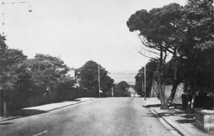 The destruction of much of his work in West Kirby allowed Grange Road to roughly double in width, encroaching much closer to the house itself and several metres of the gardens were swallowed up. A number of trees were preserved where possible and the pavement was laid around them. Two trees that survived the initial bulldozing can just be made out on the left of the adjacent photo, but they too were removed by the end of the 20th century.
This photo also shows that on the right of the road, an isolated section of the gardens survived, along with a number of trees, walls and the stone cottage formerly occupied by Charles Barlow. One of the most impressive survivors of the redevelopment has become a local landmark - the V-shaped Stone Pine, unusual to this country which sits close to the road. (More information can be found on the Great Trees website).
This corner became known as Hilbre View Public Gardens and curiously, Google Maps still retains 'Hilbre View' at the top of Grange Road, despite it not being a term in local use. Up until the mid-20th century it was still being maintained as a garden and the photograph below is a composite view from around the 1930s in which roses line one of the original paths of the Grovehill grounds.
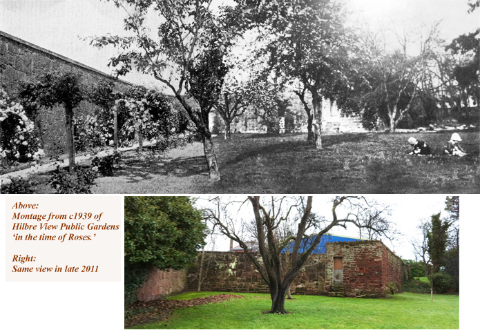
Behind the children sitting on the grass in the photo was an area of rockery which still partly survives, and a series of walls which were later removed as they were a hindrance to pedestrians on Grange Road. As traffic increased in both speed and volume as the decades wore on, it became a less and less attractive place to play until it presently has almost zero use as a public space.
 The photo on the right excludes most of the view of the road and at least gives a feel for the grounds as they might have been before the 20th century changes.
This triangle of lawn may not be filled with flowers any more but it is at least well-kept. The constant flow of cars makes it an odd place to sit and certainly it isn't a haven of tranquility.
But it is steeped in history, and well worth revisiting in the knowledge that it was once a quiet corner within the luxurious landscape of one of Wirral's finest houses.
Text, colour photographs and original research ©2011.